About MachsomWatch
MachsomWatch or Checkpoint Watch is an organization of 200 to 300 women who stand up against the occupation and for human rights. They observe what happens at the checkpoints of the separation barrier dividing Israel and Palestine and document current events or incidents at the checkpoints. That the Israeli army (Israel Defence Forces, IDF) also uses the reports as a source of information sometimes helps to improve the conditions at the checkpoints for the people who want to pass them. MachsomWatch is a feminist organization and organizes only women. The communication between women and soldiers seems to work better, so it is an advantage for them that MachsomWatch has no male members.
MachsomWatch also helps „blacklisted people“, who are denied to cross the border for any reason like work or medical care, and who are not told why. This is a big problem for people who got on such a list by accident, and MachsomWatch helped nearly 300 people to get removed from it. MachsomWatch also offers public bus tours like this one which drives us through the North of Jerusalem and towns in the adjoining West Bank to show the consequences of the occupation for the Palestinians and, as the guides accentuate: „It is not a balanced tour“.
The history of the conflict, green and blue line
In 1947, the United Nations resolution No. 181 declared that two states should be founded in the British-ruled Palestinian area: A Jewish and an Arab state. The city of Jerusalem was defined as a corpus separatum, an area independent of the two new states. But the Arabs of Palestine and the surrounding Arab states denied this plan and a civil war broke out. After the declaration of independence of Israel in 1948, five Arab states (Egypt, Syria, Jordan, Lebanon, and Iraq) invaded Israel to wipe her out. But Israel won the war. The opponents signed an armistice agreement and established an armistice line, the so called „green line“, which separated Israel from the surrounding countries, including the Jordanian-held West Bank. It divided Jerusalem into an eastern and western part and in some places within town this armistice line had the form of a wall.
This line was valid until 1967, when fighting broke out between Israel, on the one hand, and Egypt, Jordan, and Syria, on the other. Again Israel won this war which lasted six days. She conquered some areas, including the West Bank, which now was under Israeli military rule, and it annexed areas in the East of Jerusalem to expand the city of Jerusalem. Israel draws a new Municipal Border running east and north of the green line.
Palestinians who lived in the annexed area were defined as permanent residents of Jerusalem. They got a blue identity card – the same that all Israeli citizens carry – and can move freely everywhere in Israel, and can vote for the Jerusalem mayor and city council (but not for the Knesset). 372,000 people or 39% of the population of Jerusalem are Palestinians with this legal status (Remark: The data or statistic mentioned by MachsomWatch are – according to their own statement – not from official Israeli and Palestinian sources, because such information is hard to get. It comes from the United Nations or from research conducted by Israeli and Palestinian human rights organizations.). The Palestinians in the West Bank living outside the city of Jerusalem have a green identity card and for a long time, they could easily go to Israel as well. Only with the separation barrier, the difference between green and blue identity cards became vital, and Palestinians who wish to enter Israel must receive a permit from the Israeli military authorities.
The separation barrier
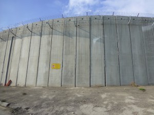
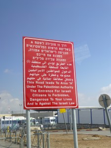
During the second Intifada, which began in 2000, the separation barrier between Israel and the West Bank was built, although prime minister Ariel Sharon first did not want it, because he feared that it could fix Israel’s border to that line. The concept for the route of the barrier was to exclude as many Palestinians as possible and to include as many Israelis living in the West Bank as possible. Up to now 40 percent of the barrier have not been finished. The barrier cuts the city of Jerusalem in two places, leaving over 90,000 Palestinian residents of the city living beyond it. West Bank Palestinians with a green identity card do not have a general permission to cross the barrier through a checkpoint; they need individual permits. Palestinian residents of Jerusalem with a blue identity card who live behind the barrier are allowed to cross it at a checkpoint, but they face all the inconvenience which comes with passing the checkpoints: They sometimes have to wait for a long time, have to bear extensive security checks, and so on.
It is a controversial question as to whether the terror declined due to the barrier or not. MachsomWatch explains the decline of terror with the political decisions of the Palestinians, who noticed that the intifada did not have any positive effects on their situation, especially after the death of Yasser Arafat in 2004, who had an ambivalent attitude towards terror. This argument is backed by the fact that the barrier is not complete yet, and that there are places where it is still possible to move from Palestine to Israel without crossing the barrier.
Problems resulting from the barrier
There is a variety of difficulties that the barrier produces. Some result from the fact that in Jerusalem, the barrier does not always surround the city; instead it twice crosses the municipal boundary into the city, creating a situation in which many Palestinian residents of Jerusalem must cross through a checkpoint to go to work, to school, to shop, and otherwise carry on their daily lives.
Bureaucratic problems created by the need to acquire permits also affect Palestinians living in Jerusalem. One example is a family with green West Bank identity cards whose house is located inside Jerusalem and who therefore should have blue identity cards. When after the war in 1967 the Palestinians in the area annexed to Israeli Jerusalem got their blue identity cards, the father of this family was issued a green one because he was working in Jordan at the time. This was normal for business or private reasons because the West Bank had been part of Jordan till then. Before the separation barrier went up, this was not a problem for him, because West Bank Palestinians with green cards were able to move freely into and out of Jerusalem.
But today, because he has a green identity card, the man is illegal in the city of Jerusalem. He cannot move around the city without the danger of getting into trouble if stopped and asked to show his identity card. And to go into the West Bank, where he could move freely, he must go through a checkpoint in the separation barrier which is open only during certain hours each day. Unfortunately the status of the family father is transferred to his children, who are in the same difficult situation now.
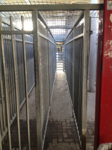
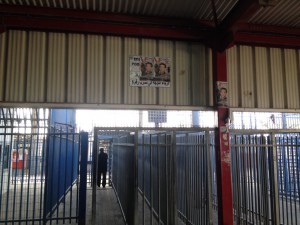
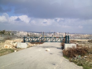
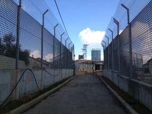
Checkpoint Qalandiya
Thousands of people pass the different checkpoints of the separation barrier every day. Often they have to wait for up to an hour to get through the stages of the checks. A saying in Palestine is: „You never ask ‚when‘ in Palestine“. But there is also a humanitarian gate for women, children, ill, old, disabled or other people with special conditions that requires a special permit. One also has to know that the soldiers who work at the checkpoints normally hate their job. It is supposed to be the worst job one can get in the army.
Other Checkpoints/Gates
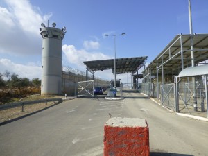
There are also checkpoints which are only accessible for special groups, e. g. diplomats, or Israelis and tourists. Even more different are so called agricultural gates,
which are open some times a year for a certain time so that Palestinian farmers canaccess the agricultural areas to work there.
ABC – The Areas in the West Bank
The Oslo Agreements in 1995 segmented the West Bank in three types of areas:
- A Area: The A-Area is under the full control of the Palestinian Authority (civil and security/military). Israelis are not allowed to enter the A area by order of the Israeli army, because it is supposed to be dangerous. The bigger cities in the West Bank are A-Area
B-Area: Villages are the B-Area. They are under the civil control of the Palestinian Authority, but under the security control of the IDF
- C-Area: The C-Area, which is 60% of the West Bank, is under full Israeli control – both military and civil.
The situation around the barrier in Kufar Aqab
Kufar Aqab was a West Bank village which was split by the annexation of part of it into Jerusalem in 1967. The bigger part of it became a neighborhood at the northern point of East Jerusalem, the smaller part stayed in the West Bank. When the separation barrier was built, it cut Kufar Aqab off from the rest of East Jerusalem, to the south of it. As a result, a lot of Kufur Aqab residents with blue identity cards moved to the area south of the barrier to avoid having to cross it daily to go to work and so forth. As a consequence, real estate prices south of the barrier in East Jerusalem increased so that many people couldn’t afford to live there anymore. Many of these poorer people then moved –
to Kufar Aqab, still in Jerusalem but behind the wall, and there arose a boom and the demand for cheap apartments. High-rising housing were built everywhere in Kufar Aqab. As behind the wall there is no control over the building activities by any authority, the quality of the buildings is often bad, and it might be even dangerous to live there because no one ever checked the static of the houses.
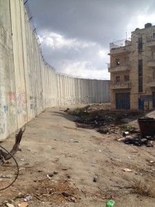
The 90,000 or so Palestinians who live within the municipal boundary of Jerusalem but behind the separation barrier pay taxes to the municipality of Jerusalem, but they get only very bad services back. The supply of water is very bad and the conditions of the streets as well. Furthermore the waste disposal doesn’t function, so a lot of trash lies beside the streets.
Bir Nabala
The West Bank Palestinian town Bir Nabala is together with three adjoining towns completely surrounded by the separation barrier, turning them into a closed enclave. Bir Nabala, which directly adjoins East Jerusalem, used to be part of the same urban space as Jerusalem, with Palestinians moving freely between the city and this West Bank suburb.
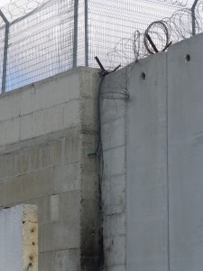
Since it has been cut off from Jerusalem by the separation barrier, Bir Nabala’s economy has been ruined. In some places in Bir Nabala one can see small ropes on the top of the separation barrier that are used to climb over it.
Lone Houses
There are some four cases in which Israeli settlements in the West Bank have been built very close to the edge of Palestinian villages. Consequently four Palestinian houses now stand where the separation barrier would have passed if there had been enough room to build it between the edge of the settlement and the edge of the village. Since in each case the Palestinian owners refused to leave their houses behind to let them be torn down, each of these houses is now surrounded by a high and elaborate fence, built by the Israeli government – supposedly to protect the Israeli settlers from the residents of the Palestinian house. The residents of these so called „lone houses“ are living in a terrible, prison-like atmosphere.
Water
The Palestinians who live in the West Bank and the two neighborhoods of East Jerusalem behind the separation barrier often have problems with the supply of water. The infrastructure for the supply is bad or even not existing. Often water is rationed by the Israelis, who control the water supply. Sometimes the rationing of water is organized by an Israeli settlement nearby. In many places water is supplied to the Palestinian residents only once or twice a week and is stored in tanks on the roof of a house or apartment building to be „self-rationed“ by the inhabitants so that it lasts until the next supply day. If the supply runs out, people must purchase water, delivered by tank wagons, at great expense. The large black roof tanks are the obvious distinction between Israeli and Palestinian settlements in the West Bank.
Links and References
Recommendations by MachsomWatch
Idith Zertal: „Lords of the Land: The War Over Israel’s Settlements in the Occupied Territories, 1967-2007“
Gershom Gorenberg: „The Accidental Empire: Israel and the Birth of the Settlements, 1967-1977“
Kalandia – A Checkpoint Story, filmed and directed by Neta Efroni (a member of MachsomWatch), narration in English: https://www.youtube.com/watch?v=kiPpSU42MTY
Many maps of the Palestinian Territories are available on the website of the UN Office for the Coordination of Humanitarian Affairs: http://www.ochaopt.org/index.aspx